Saturday, August 31, 2013

Just Being a Tourist

Today we decided to visit several tourist attractions.  We chose to start with one we wanted to see and learn about - the Crazy Horse Memorial.  It is a truly massive undertaking.  The sculpture was begun in 1948 and will be the largest sculpture in the world when it is finished.  It was inspiring to see this beloved Indian leader emerging from the rock of the mountain.


We watched a film on the inception of the Crazy Horse Memorial and how it is being created.  I would love to be there when they are actually doing some of the explosive "carving."  The model of the sculpture is beautiful and in one picture, we actually captured both model and sculpture.

 You can see the lines on the right where the horse's head will emerge.


The grounds of the Crazy Horse Memorial house a visitor center, museum, gift shop, and sculptor's studio.  We examined many artifacts, photos, and stories while at the museum and it left us puzzled and saddened by the dreadful treatment of our Indian brothers and sisters.  It is clear that a deep lack of communication and an unwillingness to bridge a cultural gap lead to loss and bloodshed and a lingering feeling of mistrust.  I understand why the association that continues to build the memorial does not want to take federal funding or assistance for this effort.


We drove north from the Crazy Horse Memorial to the town of Hill City to find the Museum at Black Hills Institute to see the dinosaur bones and other geological finds.  It was small but fun.  The T-Rex skeleton was huge.  I can't imagine how much work and digging it took to get that whole skeleton out of the earth.  We found some smaller skeletons that were photo-worthy, too.  I couldn't get Stan (the T-Rex) all in one photo.

 Info on Stan

 Stan

Dennis' new pet

After the dry work of geology, we went to visit a winery, Stone Faces Winery, just north of Hill City.  The people were friendly and we sampled sips of several South Dakota wines and bought a few.  It was amazing to me that grapes could be grown in South Dakota, but the person who was helping us sample said that the grapes came from the southeast corner of the state where there was more water and a more moderate climate.  I am not complaining about dry weather!  We have had perfect, sunny, warm days and that has suited our travels just fine.

As we came back into Custer, I told Dennis I wanted to stop at the National Woodcarver's Museum.  This turned out to be kind of a waste of our money.  It was not what I expected.  I envisioned fabulous artistic works of wood carving from a variety of artists.  It was the work of one man and the carvings were like cartoons - many of them animated.  The displays were dated in feeling and presentation.  The final blow was that many carvings in the gift shop were from other countries.  I thought they were totally missing an opportunity to showcase American arts and crafts.  It was disappointing.

Tomorrow we plan to visit Wind Cave for an underground adventure.  Walking shoes and warmer clothes are in order for us!

...Where the Buffalo Roam

Notes from Friday, August 30:  We carry the curse of being morning people no matter what time zone we inhabit.  So, we got up at 6:00 am and made coffee and discussed our plans for the day.  It was too cool to sit on the porch this morning and it rained a bit.  We determined our path and then I made breakfast for us.  Then we both showered and dressed and hit the road.

Morning view from our cabin

Our plan was to take the Needles Highway up to Mt Rushmore and take the Iron Mountain Highway back to Custer State Park and drive the Wildlife Loop.  We accidentally turned onto the Iron Mountain Highway instead.  As it turned, that was a happy mistake because the Iron Mountain road was the place to be.  We were stopped by a highway worker when the road turned to a one lane road because of construction.  She told us that there was "difficulty with the buffalo" this morning and she did not know how long we would have to wait.  After about ten minutes, the lead truck came for us and we moved forward - slowly.


We found ourselves surrounded by bison.  They were taking their time and taking their share of the road.  Since the bison are so much bigger than most cars, we all let them have the right of way.  This was our first chance to take pictures of bison and we took lots!  After we passed the herd (or they passed us), we continued on toward Mt Rushmore.  The road had three one-lane tunnels on the way.  One tunnel framed the president faces - very cool.

Look closely above the oncoming car.

When we got close to the Mt Rushmore entrance, there was a pull-off so we cold take a long distance picture.  The National Monument was not wildly busy (Remember that morning people thing?  There are benefits.) so we found a good parking place and headed up to the monument.  It was a beautiful clear day and we had many opportunities to take great pictures of Mt Rushmore as a whole and of each president individually.  Washington and Lincoln are the most compelling, but I wanted to spend some time with Jefferson and Roosevelt - we would live in a very different nation without them!  As we have traveled through the mountains, Dennis and I have commented that the rocky hillsides often seem to contain faces.  When we took pictures of the whole scope of Mt Rushmore, we thought we could still see potential faces in the un-carved rock next to the presidents.

 Faces from a distance
 Faces carved and un-carved
Mt Rushmore's grandeur

I have to admit that I was most strongly attracted to the Lincoln sculpture.  Several times as we walked and viewed, it looked like he was looking right at me - probably saying that the work he started is not done and I should get about helping.  The monument is an impressive sculpture and a real tribute to perseverance and to having a vision.  We were both in a reflective mood when we left.


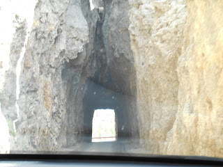
We drove back on the Needles Highway.  Oh my goodness, what a road!  It did not just curve, it jackknifed.  There were many times when we thought oncoming cars wold just crash into us.  And several tunnels and passes were carved out of solid rock and only carved to hold one car at a time.  The needles for which the highway was named are giant, jagged pillars of stone.

 The Needles
The eye of the Needles

After we came down from the heights of Needles Highway, we drove the Wildlife Loop and finally saw lots of wild life.  We saw more bison, wild burros, pronghorn deer.  It was great to see the animals up close in their environment.  Seeing the wildlife was a great way to end today's tour.

 Big, up close bison - still roaming
 Wild burro, hoping wild Dennis will feed him even though it's against the rules.
 Pronghorn deer keeping their distance.

Thursday, August 29, 2013

Devils Tower and on into South Dakota

We are spending four days in the Black Hills area of South Dakota, so we decided to stop at Devils Tower in Wyoming today on our way to South Dakota.  Our hotel last night was disappointing and not real clean, but it was quiet.  We vowed that we would not stay in hotels that don't feel right to us from now on.  Of course this was easy to do in light of the fact that I had already reserved a cabin for four nights - now we had to hope it was a nice cabin!

We drove the two and a half hours to Devils Tower with no problem.  Dennis had been there when he was a kid on a family camping trip.  I have never been to any part of Wyoming and had only experienced Devils Tower by seeing its majesty in Close Encounters of the Third Kind.  It is a stunning sight.  I had to read about the geology of the Devils Tower and now I know what a butte is. 

 Devils Tower from a distance
 From a distance with zoom lense

We could see it for several miles before we arrived at the National Monument entrance.  I have to give a big hurrah to the National Forest Service!  In our travels we have noticed that the Forest Service does a great job of maintaining our national park lands and does a great job of showing them to best advantage.  In Glacier National Park and at Garnet Ghost Town and at Devils Tower the park service has been careful to offer excellent opportunities to get great pictures.  Approaching Devils Tower there are pull offs where visitors can take great long distance shots (even goofy shots like Dennis holding the monument).  And on the 1.3 mile trail around the bottom of Devils Tower there are benches and small shady spots where a photographer can get a clear shot.  I really appreciated this today.

 Devils Tower from the foot of the butte
 Do you see the rock climber in this picture?
 The Tower through the trees.
 Dennis holding the Tower in his hands.
Dennis got this picture of a golden eagle flying over the Tower.

I would love to show you all of the awesome pictures we took, but there were more than 70!  I wanted to get photos of the Tower from every side.  It was a beautiful sunny day, perfect for showing the shadows and columns of the monument.  We walked and stopped and took pictures and talked to other tourists and heard the languages of the many visitors to this location.  It was fun.

When we jumped back on the road again, we took state roads south through rural Wyoming until we reached US 16.  We turned east and headed into South Dakota.  Our destination was Custer City, outside of Custer State Park.  We had to use our phones to find the bungalows where we were staying and the phone was not completely accurate.  But we got here finally and registered with our host, Scott.  We are in cabin 4 which looks out at a nice pond, lots of trees, and rocky portions of the Black Hills.  It is somewhat remote, very quiet and kind of like camping but in a really nice cabin.  The cabin has a bedroom, living room (with a TV that doesn't get a signal), a small but nice (and clean) bathroom, and, best of all, a kitchen.  The kitchen has lots of pots, pans, dishes, and silver ware.  All we had to do was go to the grocery store so I could finally fix a meal!  Yay!!  We will eat some meals in restaurants, but it is great to fix our own food.

Into South Dakota for our Black Hills adventure.

Tomorrow we will start our Black Hills exploration with Mt. Rushmore and Custer State Park.  This discovery process is the reason we travel and we are so glad we can do it.

Tuesday, August 27, 2013

Leaving Glacier and Visiting Missoula and Beyond


Yesterday we drove the entire length of the Going to the Sun Road and it was so beautiful.  Because we traveled at 8:00 in the morning there was very little traffic.  The morning light on the mountains was wonderful and we watched the mist rise up and drift away as the sun warmed the mountain valleys.


We stopped to photograph Lake Macdonald and drove by Macdonald Lodge – we didn’t think it was quite as nice or elegant as the Glacier Park Lodge, but there seemed to be a nice campground on the lakeshore.


We drove on to see Whitefish and Kallispell admiring the charm and vitality of both towns, but we headed on toward Missoula so we would have a good starting point for visiting a ghost town.  Missoula is a college town with an awesome Old Town area and lots of friendly people.  We ate dinner at the Iron Horse Brew Pub and our waitress, Amanda, told us that her family was from Michigan in the Gaylord area.  She has lived in Montana for many years now and finds it odd when they come back to visit family in Michigan to find herself surrounded (actually she said closed in) by trees.  The “Big Sky” concept gets into people and they feel too closed in when they are in the heavily treed areas of Michigan.  I love the open spaces and blue sky that we have found here, but I would miss the lush green-ness of my home state.

When we left Missoula this morning we headed out on state highway 200 for about 30 miles.  We turned into an “experimental forest” (It looked just like a real forest but there were lots of people working on different projects.) and drove down a road that became a gravel road for another 12 miles to get to Garnet, Montana’s best preserved ghost town.  Garnet was settled in 1898 and the population ballooned to over a thousand.  By 1905 the gold was gone and the population had shrunk to 150!


It was so interesting to see that a whole, small town had been built to accommodate the miners.  This town prided itself on having a family atmosphere instead of having a lawless-men-and-brothels culture.  They even built a school.  Mining tried to come back twice to Garnet but was unsuccessful both times.  Now the Forest Service and the Bureau of Land Management are working to preserve, but not improve, the buildings that remain.  It was a snapshot of history – interesting, sad, and telling of our history.


 Garnet Hotel
 Hotel Kitchen
 General Store - origin of DSW?
 Jail

We left Garnet and I asked Dennis which way he wanted to go back to I-90 – back the way we came or onto 200 east.  He opted for 200 east.  We drove and drove through cattle ranges and open country.  There were no towns, no stop signs, and, worst of all, no gas stations.  We had passed a gas station on 200 on the way to Garnet and Dennis said, “We still have a quarter of a tank.  We’ll get gas later.”  We had agreed at the beginning of the trip that we would fill the tank whenever it reached a quarter, but there is no arguing with someone who knows what he wants.

Dennis asked when we would get to a town and I said that Avon was a few miles away.  He said we would get gas there, but there was nothing there but a few houses.  He asked when we would get to the next town.  I asked how low we were and how many miles we had on the current tank.  We usually fill up around 400 miles.  We were below  a quarter tank and had more than 430 miles on this tank!  But Dennis noted that the empty tank light had not yet come on.

The nearest town was 11 miles (no gas station) and then we had another 14 miles on I-90 before we reached a town of any size.  The town was Deer Lodge.  Fortunately, there were gas stations at the first exit.  We filled up with 17.3 gallons at 473 miles on the tank and Dennis promised that we would fill up at the quarter tank mark for the rest of our journey (which will often take us through empty land).

We arrived in Butte around 3:00 and found the bed and breakfast that we are staying at tonight.  It is a large brick house on the outskirts of town operated by a nice couple that really enjoy company.  The room is beautiful and we have access to a sitting room and a small private patio.  Our host recommended a restaurant called Casagranda Steakhouse in the old section of downtown Butte and it was excellent!  We feel fortunate in our travels and our lodging and our restaurant choices.  Sometimes the unexpected is delightful.

Monday, August 26, 2013

Glacier National Park: the Sights - August 25th Post


Note:  I wrote this yesterday but the internet connection was so hideous that I got discouraged and quit trying to load it.  We are now back with internet so here is the post and lots of pictures and I added pictures to the August 24th post too.

Today was our sightseeing day.  We had breakfast and headed out to the boat launch to take one of the boat tours- this one was a tour of St Mary Lake.  The naturalist who accompanied us gave us a lot of information about the geological history of Glacier including the fact that some of the rock we were looking at was more than a billion years old.


Boat at St Mary Lake and Going to the Sun Mountain from the Lake

The boat tour dropped us off near Baring Falls and some of our companions went on to participate in a 3-mile hike out to St Mary Falls and back – another boat would pick them up.  We had chosen to stay with the 1 ½ hour tour. 


Raised valley, mountains from the Lake, and, yes, the boat did fit through this tiny gap

When we landed, we headed west on the Going to the Sun Road across the park.  We wanted to see if the St Mary Falls trailhead was open so we could do the shorter hike – but it was not.  So we drove on to see if we could park at the visitor center at Logan Pass.  We drove around the parking lot for 15-20 minutes but were unable to get a parking space, so we continued west on the Going to the Sun Road and stopped at some of the turnouts to get photos. We turned back and noticed that traffic was thinning so we stopped in the Logan Pass parking lot again and were blessed with a parking space.  We went to the visitor center; looked at the wildflower garden; took pictures at the Continental Divide and crossed the street to see what the Highline Trail looked like.  We were not going to hike it because it is 7.6 miles one way, but I wanted to see some of it. 

 One of the two fabulous tunnels on Going to the Sun Road


 Description of construction and picture of results along with picture of photographer


 Happy travelers at Logan Pass

 View of Going to the Sun Road from the Highline Trail

Dennis waited for me as I went down about two tenths of a mile and shot photos of various scenes.  I turned back to rejoin him and climbed the hardest two tenths of a mile I have ever walked.  When we relinquished our parking space, we headed back toward St Mary Lake.  As we slowed down for the Falls trailhead parking lot we found one space left – yay!  The hike was eight tenths of a mile down to the falls.  It was well worth the effort.  Our one complaint about sightseeing is that it is hard to get great photos because all the other tourists clutter up the picture and get in the way.  Still, as you can see, we managed to capture a few good scenes.


St Mary Falls

We were tired when we got back to the motel and I was proud of Dennis for sticking with our plan and hiking with me even though he has a hard time with downhill trails.  Tomorrow we will go the whole distance on the Going to the Sun Road and see Lake Macdonald, West Glacier, Whitefish and then on to Missoula.